CLANTON – Scattered showers and a few thunderstorms are forecast to occur mainly across the western half of the state today. No severe weather is expected.
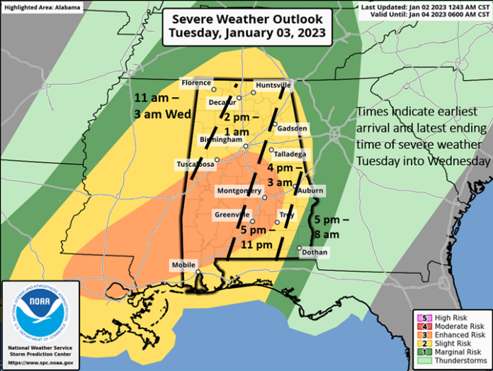
Several rounds of thunderstorms are forecast to affect the state tomorrow afternoon into Wednesday morning. Unfortunately, the atmosphere will be conducive for damaging straight-line winds, hail and tornadoes. The potential also exists for EF2 (strong) or greater tornadoes, especially in the Enhanced Risk region as shown in the graphic above.
Clusters or individual supercells are forecast from Tuesday afternoon into the evening followed by a broken line of thunderstorms ahead of a cold front moving from west to east across the state.
Total rainfall amounts will be 1-3 inches. Only localized flooding is expected if thunderstorms can repeatedly move across the same areas. Once rainfall exits the eastern sections of Alabama Wednesday morning or afternoon, rain-free conditions are forecast from Wednesday evening through at least Saturday.
Due to the prolonged time-frame for possible severe weather across the state on Tuesday, start thinking now about your action plan. If you are not at home, how will you get warnings? Where is the safest location to go to immediately when a warning is issued? (if you’re not sure ask ahead of time!)
One thing you can do is make sure your Wireless Emergency Alert (WEA) is turned on.
For an Iphone:
- Go to Settings
- Scroll down “Notifications” and press it
- Scroll all the way down and you will see “Government Alerts” including turning on and off “Emergency Alerts”
For an Android:
- Go to Settings
- Scroll down “Notifications” and press it
- Scroll down to “Advanced Settings” and press it
- Look for “Wireless Emergency Alerts” press it. You can then see if it is turned on or off
There are plenty of on-line videos to step you through the process if you need more guidance.


