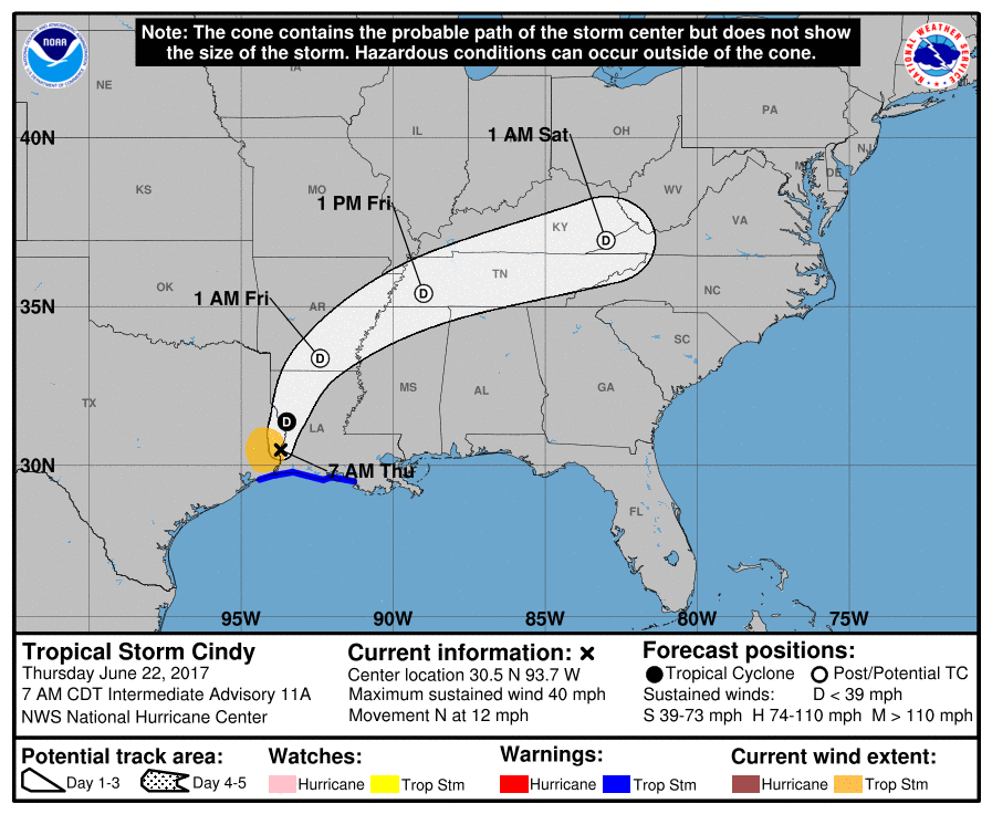
Image shows Tropical Storm Cindy’s projected path, as of 7 a.m. Thursday morning. / NOAA National Hurricane Center
CULLMAN – The current weather situation in the Gulf with Tropical Storm Cindy has warranted concerns from weather and emergency services in Cullman.
According to the National Weather Service in Huntsville (as of press time), “The National Hurricane Center is tracking Tropical Storm Cindy over the northern Gulf of Mexico. The center of Cindy is forecast to make landfall early Thursday morning along the Texas and Louisiana border, then curve northward over Arkansas early Friday. This system will draw very moist air across the Tennessee Valley, resulting in numerous showers and thunderstorms from Thursday into early Saturday.”
Phyllis Little, director of the Cullman Emergency Management Agency, says her office is on top of the storm.
“We are keeping an eye on the changing forecasts,” Little said. “Both with the hurricane and the flash flooding in south Alabama.”
Little said that, at this point, there is no anticipation of extremely dangerous weather hitting the Cullman area.
“I just came from the quarterly meeting with the North Alabama Mutual Aid, with all the other emergency services, and other than just heavy rain, we don’t expect anything affecting Cullman,” Little said. “It is not looking like there will be any tornadic activity, although you can’t ever fully rule anything like that out.”
Little also emphasizes that Cullman is better positioned to avoid flash flooding than surrounding counties.
“While we do have some flash flooding, that is usually because of drainage. Once the rain slows down, the water goes away,” she said.
The cities of Cullman and Hanceville are taking no chances, though. Both cities have picked up empty sandbags to prepare for flooding situations should they arise.
Little said people can be prepared by staying aware of the changing weather situations, and not taking unnecessary chances.
“Don’t drive into flooded areas,” she said. “There are a couple new campaigns, ‘Turn around, don’t drown,’ and ‘When thunder roars, go indoors.’”
Little said the storm shelters around the Cullman area will only be opened in the case of a tornado watch being issued.
Widespread showers, with embedded thunderstorms will affect the Tennessee Valley today and tonight. Some of the storms could become strong, producing wind gusts to 50 mph. Locally heavy rainfall is also possible today, with amounts ranging upwards of 1 to 2 inches by the late night. Localized ponding of water on area roads could occur under the heavier showers or storms.
Thunderstorm coverage will increase Friday into Friday night, as the remnants of Tropical Storm Cindy approach the area. Some of the storms during this period could become strong to severe in intensity, with damaging wind gusts and a few brief tornadoes the main threats. In addition, very high amounts of moisture associated with this system could result in very heavy rainfall, and a risk of flooding or flash flooding Friday into early Saturday. Rainfall totals into early Saturday should range from 1 to 3 inches, with higher amounts possible. Thunderstorm coverage and intensity will diminish on Saturday, and should end late Monday, as a cold front moves across the region.
Copyright 2017 Humble Roots, LLC. All Rights Reserved.


