CLANTON, Ala. – There is an Extreme Cold Warning for parts of central Alabama with Cold Weather Advisory for remainder of state. Winter Storm Watch Tuesday into Wednesday.

Cold air is rushing into the state and temperatures in far northern Alabama were already below freezing at 6 a.m. Temperatures will continue to drop across the state through the day with high temperatures from the lower 30s north of 50 south.
Snow flurries/showers are possible through this afternoon north of I-20. No impacts are expected, with some grassy areas affected. There could be up to 1/2 inch in the highest elevations of the Cumberland Plateau.
Low temperatures Monday morning will range from the single digits north to mid 20s south. Lows each morning from Tuesday through Friday will range from the teens to mid 20s. High temperatures Monday and Tuesday will range from the 20s north to 30s south, in the 30s on Wednesday and lower to middle 40s Thursday and Friday.
Areas near and north of I-20 will go below freezing from this afternoon through at least Wednesday morning. Wind chill readings during the overnight hours tonight through Thursday morning will range from 2 to -9 north and lower teens at the coast.
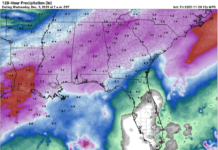
Models are now in good agreement that the bulk of the winter precipitation will be in the form of snow near and south of a Livingston – Montgomery – Auburn line. Some sleet and a small chance of freezing rain mixed with snow is still possible in far southern Alabama. The current total amount of snow/sleet map is provided below.
What is still unclear is how far north the snow will occur, as well as amounts. Near and north of I-20, it is still possible no snow could occur or higher amounts than currently forecast. Expect changes to both amounts and locations over the next 36 hours.
The precipitation will begin spreading across the state between 6 a.m. and noon Tuesday with the bulk of it between noon and 3 a.m. Wednesday.
A couple of historical things to end with. First, I’m sure most of you remember the January 2014 “Snowmageddon”. Temperature wise, next Tuesday will be very similar to 2014. What most people forget is that many locations across the I-20 corridor (where roads were a sheet of ice) had 2 inches or less of total snowfall for the 2014 event. For Tuesday into Wednesday, any snowfall, especially on untreated roads, has the potential to cause immediate and hazardous driving conditions once it begins.
Finally, Mobile has only reported 3 inches or greater snowfall 10 times since 1895! The last time this occurred was 1963.


