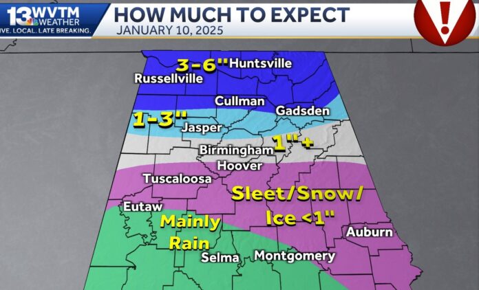
BIRMINGHAM, Ala. – Below is a Wednesday afternoon (press time) look at Friday morning’s winter storm threat.
Some basic info to know:
- Snow/ice begins to accumulate in Alabama around 3 a.m. Friday. It might sneak in a little before that west of Tuscaloosa, Jasper, and Cullman, but a 3 a.m. start time is a reasonable expectation.
- I’ve highlighted the Birmingham-Tuscaloosa area because this is where we’ll go from a better “snow” in north Jefferson County to a wintry mix over north Shelby, southwestern Jefferson, and most of Tuscaloosa County early Friday morning.
- As of this writing, expect roads to be AT LEAST slushy or completely covered in ice/snow in these three counties between 4-11 a.m. Friday.
- By early afternoon Friday, SOME of the roads in Tuscaloosa and Shelby Counties will probably be clear of significant ice/snow/sleet/slush/mess. The Birmingham metro area is on a thin line between high impact and just a temporary inconvenience. THE DIFFERENCE HERE WOULD BE SLEET. More sleet means a longer period of icy roads in Shelby and Tuscaloosa; less sleet means we clear faster.
- In Huntsville, Decatur, Cullman, Gadsden, Fort Payne, Albertville, Scottsboro, The Shoals and neighboring communities, it’s mostly snow with a little sleet. You’re going to want to stay home if you can. Plain and simple.
- Will roads be okay on Saturday? Some will be, some won’t. You’ll want to be plugged in for updates from local law enforcement and emergency managers to know how bad travel is in a particular area.
- What about Sunday? Most roads in the Birmingham area will be fine by Sunday. Cullman, Snead, Gadsden north to Huntsville? Some will, some won’t. We’ll just have to see how well the sun can work on melting all of this.
Get the latest forecast and other information at:


