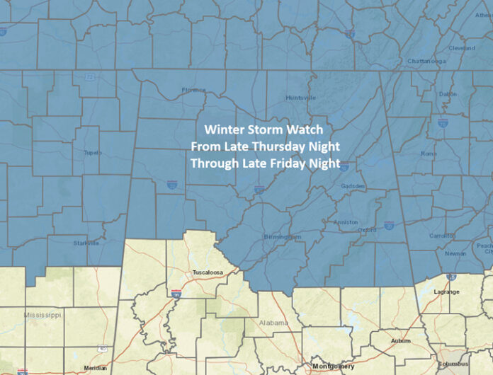
Significant impacts are likely for areas near and north of I-20.
Precipitation will begin to enter the western portions of the state after 9 pm Thursday and spread across all of Alabama between 12am and 6am Friday.
South of a Tuscaloosa to Alexander City to West Point Lake line and north of a Butler – Troy – Eufaula line, snow and sleet is initially expected, mixing with rain by mid-morning and becoming all rain by around 12pm Friday. Total snow and sleet amounts are forecast to be less than an inch, but there could still be icy bridges and some roads from early Friday through mid or late morning.
The higher impact areas continue to be somewhere around I-20 and northward. It is still unclear how far northward temperatures will get above freezing on Friday in these areas.
Around the I-20 corridor should have all snow initially, transitioning to mixed precipitation, including the potential for freezing rain around midday. Farther north, mainly snow is forecast, possibly mixed with some rain “if” temperatures can rise just above freezing.
Snowfall totals will increase significantly north of I-20. Total freezing rain amounts are forecast to be less than 0.01 inch.
Regardless of location, impacts will likely begin almost immediately on roadways once the winter precipitation starts due to how cold the pavement will become this week.


The bulk of the precipitation will move out of the state by 12 am Saturday. Temperatures will drop below freezing over much of the state early Saturday morning, which may freeze standing water on some roadways over the southern half, with continuing road impacts farther north.
It is quite possible temperatures will not get above freezing north of I-20 on Saturday, and if they do, it will only be by a few degrees. Another cold night will occur Saturday night into Sunday morning, with lows from the teens and 20s statewide.
Temperatures are forecast to finally get above freezing across Alabama by Sunday afternoon.
Finally, although models are coming into better agreement, there could still be changes to amounts, precipitation types and locations in later updates. Keep up to date with the latest forecasts from a trusted weather source.


