From Jim Stefkovich, meteorologist, Alabama Emergency Management Agency
CLANTON, Ala. – Models continue to indicate an area of low pressure will develop over the northwestern Gulf of Mexico Thursday and move northeastward, reaching the southeastern Atlantic coast on Saturday. The exact track of the low pressure system across the northern Gulf will have direct impacts on winter precipitation locations and accumulations, and there still remains uncertainties.
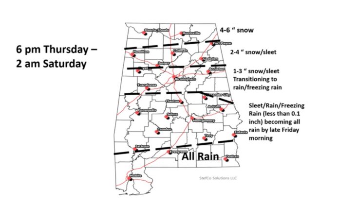
Precipitation will begin to move into western Alabama after 6 p.m. Thursday and spread across the entire state between midnight-3 a.m. Friday. The bulk of the precipitation will move out of the state by early Saturday morning.
All snow is currently near the Tennessee state line, then snow mixing with sleet and freezing rain to near I-20 or a little southward. Well south of I-20, sleet, rain and freezing rain will likely become just a cold rain by mid to late Friday morning.
Impacts will likely begin almost immediately on roadways once the winter precipitation starts due to how cold the pavement will become this week. Temperatures will drop below freezing over the northern 2/3 of the state Friday night into Saturday morning. Many areas north of I-20 may not get above freezing on Saturday which will extend road impacts and difficult to hazardous driving conditions. Temperatures are expected to get above freezing statewide by Sunday afternoon.


