Non-precipitation winds ahead of an approaching strong cold front will contain gusts from 25-40 mph beginning in the western half of the state by late morning and statewide by mid-afternoon. Behind the front, gusts from 25-35 mph will occur tonight all the way through Monday afternoon.
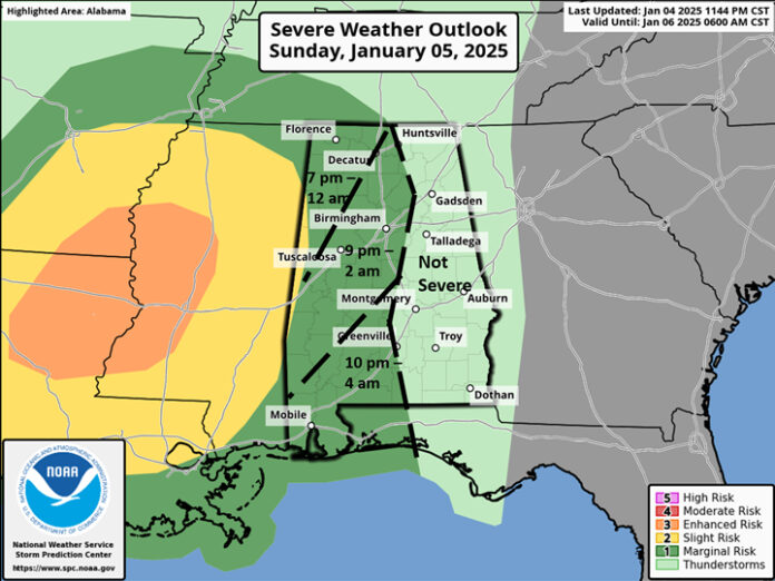
Scattered to numerous showers will continue to develop this morning through the afternoon. A line of showers and thunderstorms will move into the western sections of the state after 7 pm, reaching the center of the state between 9 pm and 4 am. A few wind gusts from 40-60 mph and a couple of tornados are possible within the line, especially in far western Alabama. The storms will be weakening as they progress eastward, and no severe weather is expected over the eastern sections of the state.
Although the bulk of the precipitation will exit southeastern Alabama Monday morning, very cold air will be rushing in behind the front and snow showers or flurries are likely from Monday morning through the evening hours in the northern sections, north of a Hamilton – Cullman – Lake Weiss line. A dusting is possible in both the higher terrain locations and across northern Morgan and Marshall counties downwind of Lake Wheeler.
Total rainfall from this system is forecast to be 1-1.5 inches across the northern half of the state with one inch or less over the southern half.
Highs on Monday will range from the 30s north to 50s south, then from the 30s north to 40s south Tuesday through Saturday. Low temperatures from Tuesday morning through Friday morning will be mostly in the 20s, but teens likely in the typical colder locations. Lows Saturday morning will be in the 20s and 30s.
Models continue to advertise a surface low pressure area developing Thursday in the northern Gulf and tracking northeastward. The exact timing and location of this track will be critical in determining where winter precipitation will occur and potential accumulations from Thursday night through Friday night.
As of now, the highest chances of snow, sleet and freezing rain is north of a Livingston – Montgomery – Auburn line, with the highest all-snow chances well north of I-20.
However, a shift in the track of the low-pressure system or temperatures just a few degrees colder could result in winter precipitation for parts of south Alabama.
Do not fall into the trap of believing any graphic/social media post about accumulating winter precipitation. It is too early to accurately predict this far in advance.


