CLANTON, Ala. — Non-precipitation wind gusts from 20-30 mph will begin Sunday morning in the western sections of the state, spread eastward by afternoon and continue statewide through Monday afternoon.
Scattered showers will occur by early Sunday morning with a low chance of very light freezing rain between 6 am – 9 am in the colder valleys of Jackson and DeKalb counties in northeast Alabama. If this occurs, a very light glaze is possible during this time period, especially on bridges. Temperatures will rise above freezing after 9 am.
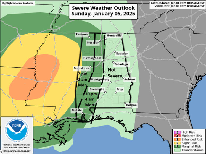
A line of showers and thunderstorms will move into the western sections of the state after 7 pm Sunday, reaching I-65 between 10 pm and 4 am Monday. A few wind gusts from 40-60 mph and a couple of tornadoes are possible within the storms, especially near the Alabama/Mississippi state line. The storms will be weakening and the severe threat will end east of I-65.
Although the bulk of the precipitation will exit southeastern Alabama Monday morning, very cold air will enter the state and snow showers are possible from Monday morning through the afternoon in the northern sections, north of a Hamilton – Cullman – Lake Weiss line. Minor accumulations are possible in the higher elevations.
In addition, several hours of favorable wind fetch across Lake Wheeler may result in accumulating snow across northern Morgan and Marshall counties. Yes, Lake Effect snow does occur in Alabama!
Total rainfall from this system is forecast to be 1-1.5 inches across the northern half of the state with one inch or less over the southern half.
Highs on Monday will range from the 30s north to 50s south, then from the 30s north to 40s south Tuesday through the following weekend (Jan 11-12). Low temperatures from Tuesday morning through the following weekend will be mainly in the 20s, but teens likely in the typical colder locations.
Models continue to advertise a surface low pressure area developing late next week in the northern Gulf which would pump moisture up and over the cold air. This is the classic setup for winter precipitation over AL sometime from late Thursday night through Friday.
However, what remains very unclear is the strength and timing of the low pressure system. Until these get resolved, there will continue to be high uncertainty in both the type and amounts of winter precipitation across the state.
Do not fall into the trap of believing any graphic/social media post about accumulating winter precipitation. It is too early to accurately predict this far in advance.
Although current forecast winter precipitation amounts and probabilities are low, it should be noted that if this event materializes, impacts are possible, especially due to the fact that temperatures will be very cold during the early part of the week. As a result, it would take less precipitation to impact already very cold roadways.


