CLANTON, Ala. – Non-thunderstorm winds at 130 pm were sustained at 15-25 mph with gusts mainly 20-30 mph.
Winds will continue to slowly increase through the evening, sustained from 15-30 mph and gusts from 30-45 mph, possibly as high as 50 mph in the higher elevations of north Alabama.
This could down some larger tree limbs or weakened trees. Also, you should secure any outdoor, lightweight objects that otherwise could be tossed around.
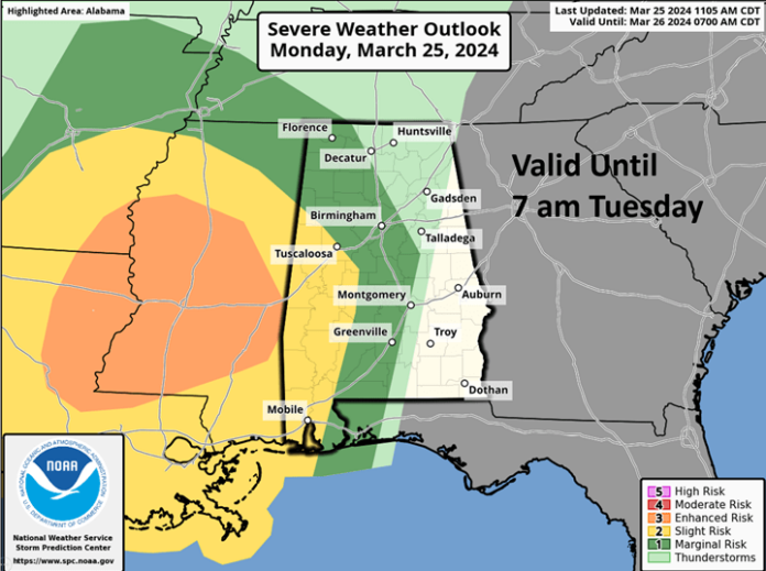
A line of strong to severe thunderstorms will enter the western sections of the state late this evening or early Tuesday morning, move eastward and exit the eastern portions of the state by early Tuesday afternoon.
The storms will weaken as they approach and then move east of I-65.
Damaging straight-line wind gusts and a few embedded tornadoes are possible in the western and southern portions of Alabama with a more isolated damaging wind threat and perhaps a brief tornado or two elsewhere across the risk area.
Since this will mainly be a night-time event, make sure you have at least two ways to receive weather warnings that will wake you up in the middle of the night.
Also, remember that except for the rare cases of extreme straight-line wind events, NWS Severe Thunderstorm Warnings WILL NOT trigger the Emergency Alert System (EAS) on your cell phone.
Many people are surprised to wake up to damage occurring in the middle of an event without their cell phone sounding an alarm.
Finally, total rainfall with this system will generally be 1-3 inches. Brief flooding may occur in urban and poor drainage areas but widespread flooding issues are not expected.


