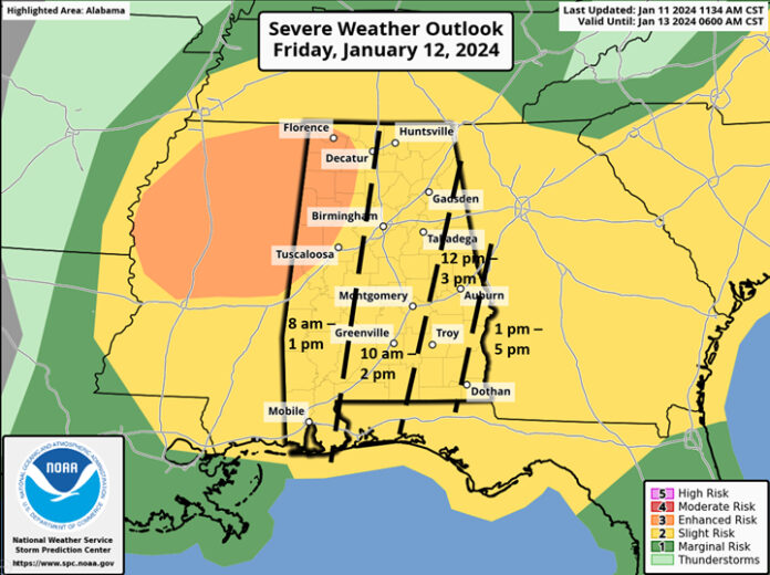
CLANTON, Ala. – In a rare “flip”, the SPC has downgraded the previous Enhanced Risk to Slight Risk and the overall threat of tornadic activity, especially EF2+ tornadoes.
However, they have upgraded northern Alabama, including an Enhanced Risk for the area west of I-65 and north of I-20 for the potential of a few damaging wind gusts of 70+ mph. A new updated graphic is provided above.
Damaging wind gusts, hail and a couple of tornadoes are all possible statewide. In the Enhanced Risk area, wind gusts of 70+ mph are also possible.
Non-Thunderstorm winds will begin to increase in western Alabama after 3 am Friday and statewide between 6 am and 9 am. Sustained winds of 20-30 mph with gusts up to 50 mph are forecast. North of a Hamilton – Cullman – Fort Payne line, sustained winds of 25-35 mph with gusts up to 55 mph will occur. These high gusts will subside between 6 pm Friday and 3 am Saturday.
Once again, the non-thunderstorm winds will likely sporadically down trees with potential power outages.
The next system could produce winter weather to portions of the state from early Monday morning into the evening hours. There is still much uncertainty with winter precipitation.
That said, the potential exists for snow across areas near and north of I-59, possibly beginning in northwestern Alabama Sunday evening (but very low chance), spreading southward on Monday and continuing through Tuesday morning. From late Monday afternoon through Tuesday morning south of I-59 to a Livingston – Troy – Eufaula line, a mixture is possible including snow, sleet and freezing drizzle/light rain.
Again, it is still too early to know specific amounts or even if the precipitation will occur, especially south of I-59.
Regardless of winter precipitation, there is high confidence of very cold air moving into the state Monday. Current forecast high temperatures will struggle to reach the mid 30s in far northern Alabama. By Tuesday morning, low temperatures will range from 10-15 degrees in the northern sections to mid 30s at the coast. Highs on Tuesday will range from the mid 20s north to lower 40s in the far south.
The coldest night will be Wednesday with morning low temperatures from the teens north to middle 20s at the coast. Highs on Wednesday will range from the mid 30s north to mid 40s at the coast.
So, the bottom line is that “if” accumulating winter precipitation occurs Monday into Tuesday, impacts could last into the middle to later part of next week.


