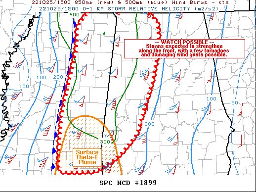
HUNTSVILLE, Ala. – Areas affected are much of eastern Mississippi into western and northern Alabama. This is concerning for Severe potential and Watch possible with a probability of a Watch Issuance…60 percent.
SUMMARY…Storms are expected to gradually increase in intensity along a cold front, with sporadic wind damage and couple tornadoes possible.
DISCUSSION…A north-south oriented line of storms currently extends from the MO Bootheel into western TN, and due south across the middle of MS. While northern parts of this line are surging quickly northeastward coincident with the shortwave trough, southern portions of the line are moving slower toward the east. Recently, lightning has been observed over central MS where MLCAPE remains below 1000 J/kg. Surface observations show warming over southern MS with temperatures in the upper 70s to near 80 F, and this degree of warming may be needed for surface-based inflow parcels initially. With time, a few cells along the front may become severe, with sections of QLCS possible. Large scale lift is more favorable farther north, but low-level convergence along the front should be enough to initiate new storms later today given robust moisture. Large looping hodographs with 0-1 SRH to 300 m2/s2 will clearly favor rotation, with a conditional threat of brief tornadoes and corridors of damaging winds. The slow eastward movement of the line, coupled with diurnal considerations, do appear favorable for a discrete supercell or two later this afternoon, most notably where southern portions of the line interact with the stronger MLCAPE. Though models differ on storm coverage, any discrete supercells in this high shear environment could result in an isolated strong tornado within a relatively narrow zone.


