HUNTSVILLE, Ala. – Hurricane Sally moved away from its predicted course through Louisiana and Mississippi that would have brought the storm into north Alabama, making landfall instead along the Alabama gulf coast. This means that when the storm makes its predicted eastward turn, it will be well south of the Cullman area. Over the next two days, if current National Weather Service (NWS) models are correct, north Alabama will not feel the brunt of Sally, but will see up to two inches of rain, leading to flooding in some areas that are low or have poor drainage, and mild winds that should not gust above around 25 miles per hour.
According to the NWS Huntsville forecaster’s notes:
“The Tennessee Valley will begin to be impacted by the remnants of Hurricane Sally in the short-term portion of the forecast. The forecast continues to be highly dependent upon the track and speed of
the storm. Hurricane Sally is forecast to make landfall early Wednesday along the Alabama Gulf Coast. Sally will then turn to the northeast but will continue to move slowly. Southern portions of the forecast area [including Cullman County] could begin to see some rain associated with Sally by Wednesday afternoon but expect best chances will be after sunset.”
Wednesday temperatures will be in the mid 70’s to low 80’s with cloudy skies over the Cullman area. The overnight hours of Wednesday and through the day on Thursday will see the greatest chance of rain in Cullman County, with chances of 60% Wednesday night and 80% Thursday, tapering off to 50% on Friday.
From the NWS Huntsville forecaster:
“The official forecast has Sally slowly moving from just inland to near Montgomery, AL late Wednesday into early Thursday. The storm will weaken significantly during this timeframe. Rainbands will begin to push north of I-20 late Wednesday into early Thursday . . . The remnants of Sally will begin to increase forward speed to the northeast during this timeframe.
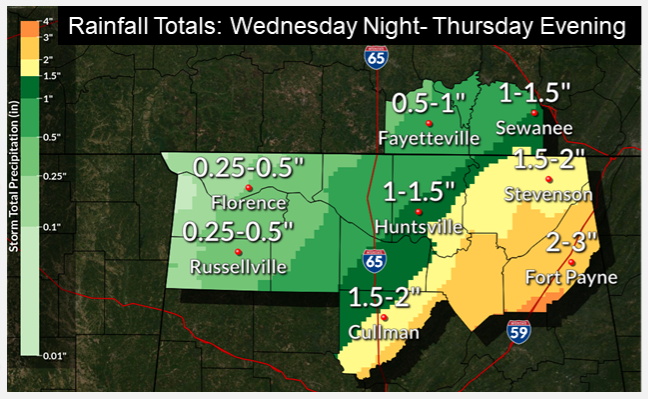
“With the center of the storm passing to the south and east, instability is almost non-existent and have no real mention of thunder in the forecast for Wednesday and Thursday. Rainfall amounts will be highly dependent on the speed and track of Sally. With the faster speed and track slightly further to the east, rainfall amounts range from less than an inch for locations generally west of I-65, to around 1-2 inches for areas east of I-65 with locally higher amounts of around 3 inches possible for far southeastern portions of the forecast area in Marshall and DeKalb counties. These rainfall amounts could lead to some flooding issues, especially in area of poor drainage.”
NWS Huntsville forecast for the Cullman area: small effects from Sally, cold front bringing fall temperatures
Wednesday – A 50 percent chance of showers, mainly after 1pm. Cloudy, with a high near 76. East wind 10 to 15 mph, with gusts as high as 25 mph. New precipitation amounts of less than a tenth of an inch possible.
Wednesday Night – Showers likely, mainly after 1am. Cloudy, with a low around 65. East northeast wind around 10 mph, with gusts as high as 25 mph. Chance of precipitation is 60%. New precipitation amounts between a quarter and half of an inch possible.
Thursday – Showers. High near 77. Northeast wind around 10 mph, with gusts as high as 20 mph. Chance of precipitation is 80%.
Thursday Night – A 50 percent chance of showers. Mostly cloudy, with a low around 62. North wind around 5 mph, with gusts as high as 20 mph.
Friday – A 30 percent chance of showers. Partly sunny, with a high near 77.
Friday Night – Mostly cloudy, with a low around 58.
Saturday – Mostly sunny, with a high near 77.
Saturday Night – Mostly clear, with a low around 54.
Sunday – Sunny, with a high near 75.
Sunday Night – Mostly clear, with a low around 54.
Copyright 2020 Humble Roots, LLC. All Rights Reserved.


